The drone: an efficient tool for stockpile calculation
In order to know precisely the volume of ore to be evacuated and treated, we carried out a survey of this stockpile.
- Flight time: 18 minutes;
- Number of pictures taken: 186;
- Ground control points: 5 ;
From the drone data, an orthomosaic of 5cm/pixel resolution is generated as well as a digital terrain model. It is from this digital terrain model that the ore volume of this stockpile is estimated. We then calculate the volume of the stockpile using two software programs that have two different estimation methods.
- Processing time: 1 day
- Estimated volume :
- Agisoft Photoscan : 50 971 m3
- Pix4d : 51 029 m3
- Margin of error between the two programs : 0,1 %
-
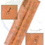
- Orthomosaïque/Orthomosaic: 5cm/pixel
-
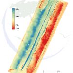
- MNT et volume mesuré/measured volume